Hilário's hobby page
This page is out of date; unfortunately, this page is unlikely to be updated.
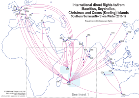
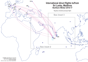
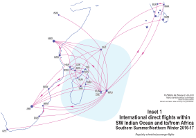
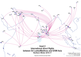
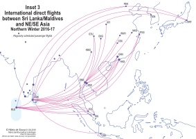
Indian Ocean international passenger flight route maps'Indian Ocean' here referrs to islands in the Indian Ocean that are 'far enough' away from the rim of the ocean. 'International' refers only to the fact that you have to go through immigration and customs at some point for these flights. All regularly-scheduled international passenger direct flights to/from the airports in this region – during Northern Winter/Southern Summer 2016-2017 – are shown in this map. (Details will be checked again as late 2016 approaches.) There are 19 airports with international flights in the region during this period; they are shown as stars on the map. Destinations outside the region are shown as circles.
Jump to:
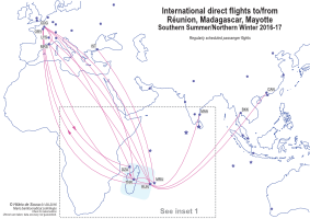
In the southwest, Comoros, Madagascar, Mauritius, Mayotte, Réunion, and Seychelles have banded together to form the Vanilla Islands tourism brand. (Maldives has dropped off from their website around late July/early August 2016.)
Compiling these maps for the Indian Ocean has been more difficult than for the Pacific Ocean, for a number of reasons. The first reason is that the Indian Ocean Islands are much less remote than the Pacific Islands. The Indian Ocean Islands also have a wider and more-diverse 'visitor catchment' than the Pacific Islands. The flight route networks are more complex. I initially envisaged drawing three maps for this region; I ended up having to draw six, due to the complexity. The second reason, related to the first, is that due to the larger number of tourists, the seasonal-fluctuation in the number of flights and routes are more noticable in the Indian Ocean than in the Pacific Ocean. Routes of the airlines based in the region are not as consistent over the years, as the pattern of buisness and tourism movement changes more rapidly, given that the Indian Ocean islands see a more diverse pool of visitors than the Pacific islands. I have less confidence in the accuracy of the information presented here for the Indian Ocean than that in the Pacific Ocean page.
Not shown in these maps are charter flights and seasonal flights in other seasons. This region sees a lot of tourism-oriented charter flights, many of them longhaul from Europe and East Asia. Some of the more interesting 'non-regular' flights are Saint-Pierre ZSE in Réunion to Rodriges RRG in Mauritius, and Christmas Island XCH to Jakarta CDG.
International airports
The following are the 19 airports with regular international flights in the region during this season, plus some other names associated with them. (The datalist below work best with Firefox; you can otherwise do a text-search (cltr+F/⌘+F) on the following texts.)
Type place name in this box:
- Mauritius MRU (FIMP, Sir Seewoosagur Ramgoolam, Port Louis)
- Saint-Denis RUN (FMEE, Roland Garros, Gillot, Sainte-Marie, Réunion, France)
- Saint-Pierre ZSE (FMEP, Pierrefonds, Réunion, France)
- Antananarivo TNR (FMMI, Ivato, Tananarive, Madagascar)
- Toamasina TMM (FMMT, Tamatave, Madagascar)
- Antsiranana DIE (FMNA, Arrachart, Diego-Suárez, Madagascar)
- Nosy Be NOS (FMNN, Fascene, Madagascar)
- Mahajanga MJN (FMNM, Amborovy, Philibert Tsiranana, Majunga, Madagascar)
- Dzaoudzi DZA (FMCZ, Pamandzi, Mayotte, France)
- Anjouan AJN (FMCV, Ouani, Comoros)
- Mohéli MWA (FMCI, Bandar Es Eslam, Comoros)
- Moroni HAH (FMCH, Hahaya, Prince Saïd Ibrahim, AIMPSI, Comoros)
- Mahé SEZ (FSIA, Pointe Larue, Victoria, Seychelles)
- Malé MLE (VRMM, Hulhulé, Ibrahim Nasir, Maldives)
- Hanimaadhoo HAQ (VRMH, Haa Dhaalu, Maldives)
- Colombo CMB (VCBI, Bandaranaike, Katunayake, Negombo, Sri Lanka)
- Mattala HRI (VCRI, Hambantota, Rajapaksa, Sri Lanka)
- Christmas Island XCH (YPXM, Australia)
- Cocos (Keeling) Islands CCK (YPCC, Australia)
International airlines and flights
The following are the airlines and routes involved (Note that airlines do not necessarily have rights to sell tickets for sectors flown entirely outside of their own countries.) (The datalist below work best with Firefox; you can otherwise do a text-search (cltr+F/⌘+F) on the following texts.):
Type name of airport/airline in this box:
- Moroni HAH – Dzaoudzi DZA
- Mohéli NWA – Dzaoudzi DZA
- Anjouan AJN – Dzaoudzi DZA
- Moroni HAH – Mahajanga MJN
- Moroni HAH – Antananarivo TNR
- Moroni HAH – Dar es Salaam DAR
- Anjouan AJN – Dzaoudzi DZA
- Mohéli NWA – Dzaoudzi DZA
- Dzaoudzi DZA – Moroni HAH
- Dzaoudzi DZA – Anjouan AJN
- Dzaoudzi DZA – Antsiranana DIE
- Dzaoudzi DZA – Mahajanga MJN
- Dzaoudzi DZA – Nosy Be NOS
- Dzaoudzi DZA – Antananarivo TNR
- Saint-Denis RUN – Mauritius MRU
- Saint-Denis RUN – Dzaoudzi DZA
- Saint-Denis RUN – Antananarivo TNR
- Saint-Denis RUN – Nosy Be NOS
- Saint-Denis RUN – Toamasina TMM
- Saint-Denis RUN – Mahé SEZ
- Saint-Denis RUN – Johannesburg JNB
- Saint-Denis RUN – Moroni HAH
- Saint-Denis RUN – Paris CDG
- Saint-Denis RUN – Bangkok BKK
- Saint-Denis RUN – Chennai MAA
- Saint-Pierre ZSE – Mauritius MRU
- Dzaoudzi DZA – Paris CDG
- Antananarivo TNR – Marseille MRS
- Antananarivo TNR – Paris CDG
- Antananarivo TNR – Moroni HAH
- Antananarivo TNR – Saint-Denis RUN
- Antananarivo TNR – Saint-Denis RUN – Guangzhou CAN
- Antananarivo TNR – Mauritius MRU
- Antananarivo TNR – Mahé SEZ
- Toamasina TMM – Saint-Denis RUN
- Antsiranana DIE – Dzaoudzi DZA
- Mahajanga MJN – Dzaoudzi DZA
- (There are also many triangular flights amongst the shorthaul destinations.)
- Mahé SEZ – Mauritius MRU
- Mahé SEZ – Antananarivo TNR
- Mahé SEZ – Johannesburg JNB
- Mahé SEZ – Paris CDG
- Mahé SEZ – Abu Dhabi AUH
- Mahé SEZ – Mumbai BOM
- Mahé SEZ – Beijing PEK
- Mauritius MRU – Saint-Denis RUN
- Mauritius MRU – Saint-Pierre ZSE
- Mauritius MRU - Antananarivo TNR
- Mauritius MRU – Cape Town CPT
- Mauritius MRU – Durban DUR
- Mauritius MRU > Maputo MPM > Durban DUR > Mauritius MRU
- Mauritius MRU – Johannesburg JNB
- Mauritius MRU – Nairobi NBO
- Mauritius MRU > Dar es Salaam DAR > Nairobi NBO > Mauritius MRU
- Mauritius MRU – Paris CDG
- Mauritius MRU – London LHR
- Mauritius MRU – Dubai DXB
- Mauritius MRU – Delhi DEL
- Mauritius MRU – Mumbai BOM
- Mauritius MRU > Bengaluru BLR > Chennai MAA > Mauritius MRU
- Mauritius MRU – Chengdu CTU
- Mauritius MRU – Beijing PEK
- Mauritius MRU – Shanghai PVG
- Mauritius MRU – Hong Kong HKG
- Mauritius MRU – Singapore SIN – Kuala Lumpur KUL
- Mauritius MRU – Perth PER
- Dar es Salaam DAR – Moroni HAH
- Nairobi NBO – Moroni HAH
- Nairobi NBO – Moroni HAH
- Nairobi NBO – Dzaoudzi DZA
- Nairobi NBO – Antananarivo TNR
- Nairobi NBO – Mahé SEZ
- Addis Ababa ADD – Mahé SEZ
- Johannesburg JNB – Antananarivo TNR
- Johannesburg JNB > Nosy Be NOS > Beira BEW > Johannesburg JNB
- Johannesburg JNB – Mauritius MRU
- Paris ORY > Dzaoudzi DZA > Antananarivo TNR > Paris ORY
- Paris ORY – Saint-Denis RUN
- Paris ORY – Mauritius MRU
- Paris ORY – Saint-Denis RUN
- Paris CDG – Mauritius MRU
- Paris CDG – Antananarivo TNR
- Paris CDG – Marseille MRS – Saint-Denis RUN
- Paris CDG – Lyon LYS – Saint-Denis RUN
- Frankfurt FRA – Mauritius MRU
- Frankfurt FRA – Mahé SEZ
- Frankfurt FRA – Malé MLE
- Vienna VIE – Mauritius MRU (northern winter)
- Vienna VIE – Malé MLE (northern winter)
- Vienna VIE – Colombo CMB (northern winter)
- London LGW – Mauritius MRU
- Johannesburg JNB – Mauritius MRU
- London LGW – Malé MLE (northern winter)
- London LGW – Colombo CMB (northern winter)
- Amsterdam AMS – Colombo CMB (northern winter)
- Zürich ZRH – Mauritius MRU (northern winter)
- Zürich ZHR – Malé MLE (northern winter)
- Cologne-Bonn CGN – Mauritius MRU
- Frankfurt FRA – Mauritius MRU (northern winter)
- Frankfurt FRA – Malé MLE (northern winter)
- Milan MXP – Mauritius MRU
- Moscow SVO – Malé MLE
Ukrainian International Airlines (PS):
- Kiev KBP – Colombo CMB
- Istanbul IST – Mauritius MRU – Antananarivo TNR
- Istanbul IST – Mahé SEZ
- Istanbul IST – Malé MLE – Colombo CMB
- Dubai DXB – Mahé SEZ
- Dubai DXB – Mauritius MRU
- Dubai DXB – Malé MLE
- Dubai DXB – Malé MLE - Colombo CMB
- Dubai DXB – Colombo CMB
- Dubai DXB > Malé MLE > Colombo CMB > Dubai DXB
- Dubai DXB – Colombo CMB
- Dubai DXB > Colombo CMB > Mattala HRI > Dubai DXB
- Abu Dhabi AUH – Mahé SEZ
- Abu Dhabi AUH – Malé MLE
- Abu Dhabi AUH – Colombo CMB
- Abu Dhabi AUH > Colombo CMB > Mattala HRI > Abu Dhabi AUH
- Abu Dhabi AUH > Mattala HRI > Colombo CMB > Abu Dhabi AUH
- Sharjah SHJ – Colombo CMB
- Doha DOH – Mahé SEZ
- Doha DOH – Malé SEZ
- Doha DOH – Colombo CMB
- Muscat MCT – Colombo CMB
- Riyadh RUH – Malé MLE – Colombo CMB
- Jeddah JED – Colombo CMB
- Kuwait KWI – Colombo CMB
- Malé MLE – Bangkok DMK – Chengdu CTU
- Malé MLE – Bangkok DMK – Chongqing CKG
- Malé MLE – Bangkok DMK – Xi'an XIY
- Malé MLE – Bangkok DMK – Wuhan WUH
- Malé MLE – Bangkok DMK – Changsha CSX
- Malé MLE – Bangkok DMK – Nanjing NKG
- Malé MLE – Thiruvananthapuram TRV
- Malé MLE – Chennai MAA – Dhaka DAC
- Hanimaadhoo HAQ – Thiruvananthapuram TRV
- Malé MLE – Beijing PEK – Tokyo NRT
- Malé MLE – Shanghai PVG
- Malé MLE – Kuala Lumpur KUL
- Malé MLE – Jeddah JED
- (There are more.)
- Colombo CMB – Mahé SEZ
- Colombo CMB – Malé MLE
- Colombo CMB – Bahrain BAH
- Colombo CMB – Muscat MCT
- Colombo CMB – Chennai MAA
- Colombo CMB – Dhaka DAC
- Colombo CMB – Kolkata CCU
- Colombo CMB – Lahore LHE
- Colombo CMB – Madurai IXM
- Colombo CMB – Jakarta CGK
- Colombo CMB – Malé MLE
- Colombo CMB – Abu Dhabi AUH
- Colombo CMB – Bengaluru BLR
- Colombo CMB – Bangkok BKK
- Colombo CMB – Bangkok BKK – Guangzhou CAN
- Colombo CMB – Bangkok BKK – Hong Kong HKG
- Colombo CMB – Beijing PEK
- Colombo CMB – Chennai MAA
- Colombo CMB – Dammam DMM
- Colombo CMB – Delhi DEL
- Colombo CMB – Doha DOH
- Colombo CMB – Dubai DXB
- Colombo CMB – Guangzhou CAN
- Colombo CMB – Jeddah JED
- Colombo CMB – Karachi KHI
- Colombo CMB – Kochi COK
- Colombo CMB – Kuala Lumpur KUL
- Colombo CMB – Kunming KMG
- Colombo CMB – Kuwait KWI
- Colombo CMB – London LHR
- Colombo CMB – Mumbai BOM
- Colombo CMB – Tokyo NRT
- Colombo CMB – Riyadh RUH
- Colombo CMB – Shanghai PVG
- Colombo CMB – Singapore SIN
- Colombo CMB – Thiruvananthapuram TRV
- Colombo CMB – Tiruchirappalli TRZ
- Chennai MAA – Thiruvananthapuram TRV – Malé MLE
- Bengaluru BLR – Malé MLE
- Delhi DEL – Colombo CMB
- Chennai MAA – Colombo CMB
- Kochi COK – Malé MLE
- Chennai MAA – Colombo CMB
- Madurai IXM – Colombo CMB
- Mumbai BOM – Colombo CMB
- Singapore SIN – Malé MLE
- Singapore SIN – Colombo CMB
- Singapore SIN – Malé MLE
- Singapore SIN – Malé MLE
- Kuala Lumpur KUL – Malé MLE
- Kuala Lumpur KUL – Colombo CMB
- Kuala Lumpur KUL – Mauritius MRU
- Kuala Lumpur KUL – Colombo CMB
- Kuala Lumpur KUL – Colombo CMB
- Bangkok BKK – Colombo CMB
- Bangkok BKK – Malé MLE
- Hong Kong HKG – Malé MLE
- Hong Kong HKG – Colombo CMB
- Chengdu CTU – Colombo CMB
- Guangzhou CAN – Malé MLE
- Kunming KMG – Colombo CMB – Malé MLE
- Shanghai PVG – Colombo CMB
- Seoul ICN – Colombo CMB – Malé MLE
- Perth PER – Christmas Island XCH
- Perth PER – Cocos (Keeling) Islands CCK
- Christmas Island XCH – Cocos (Keeling) Islands CCK
- (Six flight numbers, operated as two triangular flights departing from Perth PER each week, once in each direction. Passengers travelling between Australia and Christmas Island or Cocos (Keeling) Islands pass through immigration and customs in Australia, similar to how Australia treats Norfolk Island.)
Domestic airlines
Some more additional information that is not shown in the map. The following are the airlines with domestic passenger flights that I know of.
- Air Mauritius (MK) (Mauritius MRU – Rodrigues RRG)
- Air Madagascar (MD)
- Int'Air Îles (I7) (Comoros)
- AB Aviation (Y6) (Comoros)
- Air Seychelles (HM) (Mahé SEZ – Praslin PRI)
- Maldivian (Q2)
- Flyme (VP) (Maldives)
- Cinnamon Air (C7) (Sri Lanka)
- Helitours (Sri Lanka)
Some other interesting destinations in the Indian Ocean reachable by regular domestic flights are Socotra (but, the war in Yeman), Lakshadweep (permit required), and Andamans (premit required for non-Indians). Some further reading.
Back to Hobby Back to Network Maps Back to Past Maps and Pages